
File:Horst graben.jpg
無更高解析度可提供。
Horst_graben.jpg (271 × 135 像素,檔案大小:41 KB,MIME 類型:image/jpeg)
摘要
| 描述 |
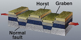
Deutsch: Diagram zur geolog. Struktur von Horsten und Graben.
|
|||
| 日期 | 日期不明 | |||
| 來源 | https://earthquake.usgs.gov/learning/glossary.php?term=graben | |||
| 作者 | U.S. Geological Survey | |||
| 授權許可 (重用此檔案) |
|
|||
| 其他版本 |
此檔案衍生的作品: |

|
File:Fault-Horst-Graben.svg是本檔案的向量版本。 如果品質不低,就應該優先使用該檔案,而非JPG檔案。
File:Horst graben.jpg → File:Fault-Horst-Graben.svg
更多資訊請參閱Help:SVG/zh。 |
 |
檔案歷史
點選日期/時間以檢視該時間的檔案版本。
| 日期/時間 | 縮圖 | 尺寸 | 使用者 | 備註 | |
|---|---|---|---|---|---|
| 目前 | 2008年12月6日 (六) 13:29 | | 271 × 135(41 KB) | Woudloper | {{Information |Description=Schematic cross-section through part of the upper crust under extensional tectonics where horsts and grabens formed. |Source= |Date= |Author= |Permission= |other_versions= }} {{PD-USGov-USG |
| 2005年12月13日 (二) 17:48 |  | 346 × 260(19 KB) | Angrense | Diagram of a rift formation. Source: {{PD-USGov-Interior-USGS}} from http://earthquake.usgs.gov/image_glossary/horst.html | |
| 2005年8月25日 (四) 17:36 |  | 346 × 260(19 KB) | Slawojar | geological structure of horst and graben {{PD-USGov-USGS}} en:Image:Horst graben.jpg Category:Geology |
檔案用途
沒有使用此檔案的頁面。
全域檔案使用狀況
以下其他 wiki 使用了這個檔案:
- ast.wikipedia.org 的使用狀況
- az.wikipedia.org 的使用狀況
- bg.wikipedia.org 的使用狀況
- bn.wikipedia.org 的使用狀況
- ca.wikipedia.org 的使用狀況
- da.wikipedia.org 的使用狀況
- en.wikipedia.org 的使用狀況
- en.wikibooks.org 的使用狀況
- eu.wikipedia.org 的使用狀況
- fa.wikipedia.org 的使用狀況
- fi.wikipedia.org 的使用狀況
- fr.wikipedia.org 的使用狀況
- gl.wikipedia.org 的使用狀況
- he.wikipedia.org 的使用狀況
- hy.wikipedia.org 的使用狀況
- id.wikipedia.org 的使用狀況
- it.wikipedia.org 的使用狀況
- it.wikibooks.org 的使用狀況
- it.wikiversity.org 的使用狀況
- ja.wikipedia.org 的使用狀況
- ka.wikipedia.org 的使用狀況
- kk.wikipedia.org 的使用狀況
- ko.wikipedia.org 的使用狀況
- nn.wikipedia.org 的使用狀況
- no.wikipedia.org 的使用狀況
- pl.wiktionary.org 的使用狀況
- pt.wikipedia.org 的使用狀況
- rm.wikipedia.org 的使用狀況
- ru.wikipedia.org 的使用狀況
- sk.wikipedia.org 的使用狀況
- tg.wikipedia.org 的使用狀況
檢視此檔案的更多全域使用狀況。