
File:Venice Lagoon December 9 2001.jpg
預覽大小:512 × 599 像素。 其他解析度:205 × 240 像素 | 410 × 480 像素 | 656 × 768 像素 | 875 × 1,024 像素 | 1,750 × 2,048 像素 | 3,580 × 4,189 像素。
原始檔案 (3,580 × 4,189 像素,檔案大小:11.35 MB,MIME 類型:image/jpeg)
摘要
| 描述 |
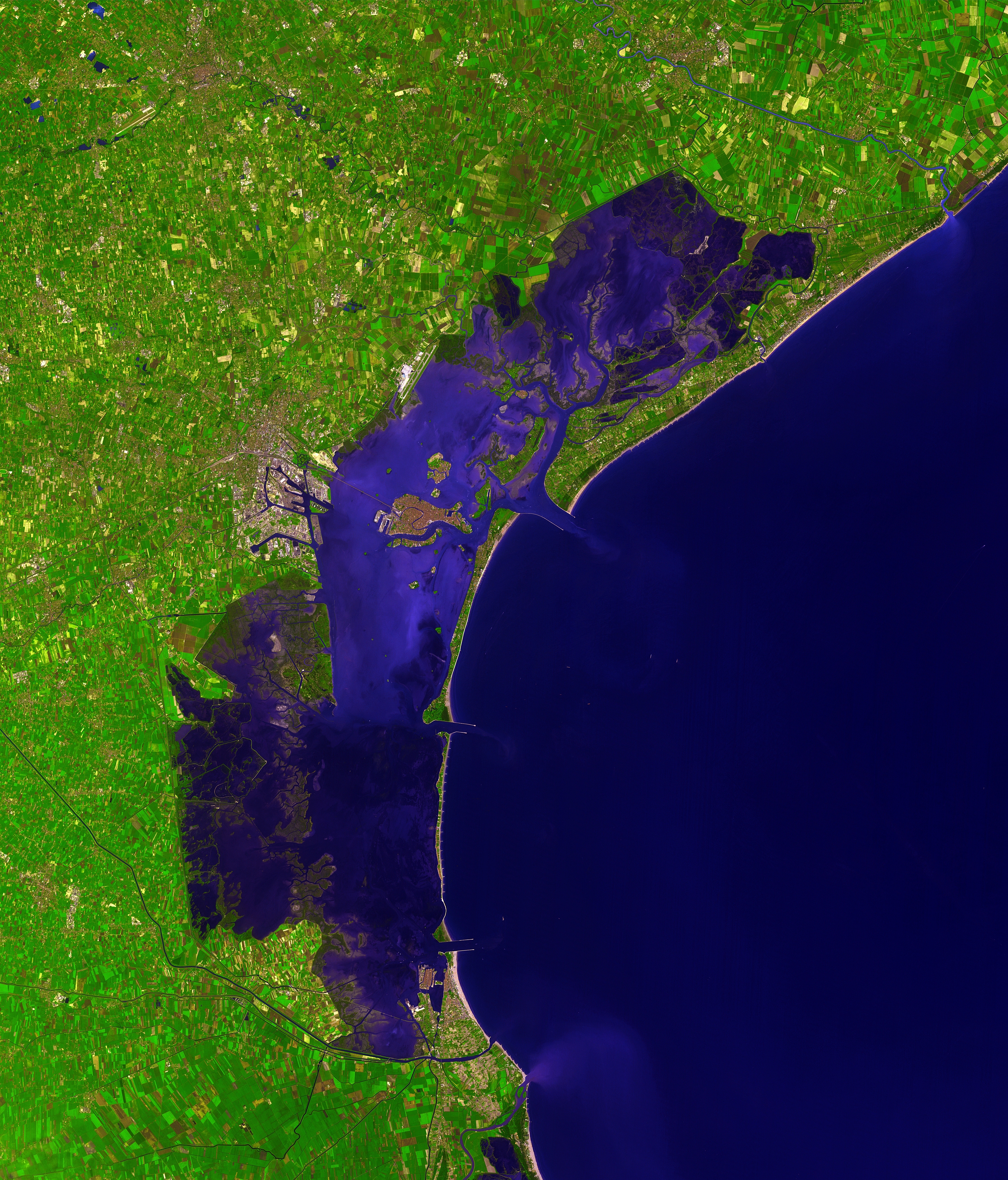
Deutsch: Dieses Satellitenbild der Lagune von Venedig wurde von ASTER (Advanced Spaceborne Thermal Emission and Reflection Radiometer) aufgenommen, einem Aufnahmesystem an Bord des Satelliten Terra der Teil des NASA Earth Observing System (EOS) ist. Das Bild wurde am 9. Dezember 2001 erstellt und deckt eine Fläche von 39 x 35 km ab. (Simulierte Naturfarben)
English: This picture of the Venetian Lagoon was taken by ASTER (Advanced Spaceborne Thermal Emission and Reflection Radiometer), an imaging instrument flying on Terra, a satellite part of NASA's Earth Observing System (EOS). It covers an area of 39 x 35 km and was acquired on December 9, 2001. (simulated natural color)
Français : Image de la lagune de Venise prise par l'instrument d'imagerie ASTER (Advanced Spaceborne Thermal Emission and Reflection Radiometer) embarqué sur le satellite Terra, lancé dans le cadre du programme EOS (Earth Observing System, ou Système d'Observation de la Terre). Aire couverte: 39 x 35 km, Couleurs naturelles simulées. Image prise le 9 décembre 2001.
Italiano: Questa immagine della Laguna di Venezia è stata ripresa da ASTER (Advanced Spaceborne Thermal Emission and Reflection Radiometer), uno strumento installato su Terra, un satellite della NASA Earth Observing System (EOS). Copre un'area di 39 x 35 km ed è stata ripresa il 9 dicembre 2001. (colori naturali simulati) |
| 日期 | |
| 來源 | http://earthobservatory.nasa.gov/Newsroom/NewImages/images.php3?img_id=16314 |
| 作者 | NASA/GSFC/MITI/ERSDAC/JAROS, and U.S./Japan ASTER Science Team |
| 其他版本 |
 |
| 拍攝地點 | | 位於此地的本圖片與其他圖片: OpenStreetMap |
|---|
|

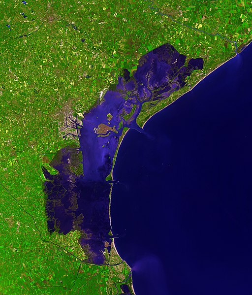
This image was selected as picture of the day on Wikimedia Commons for 15 September 2007. It was captioned as follows: English: Satellite photo of the Venetian Lagoon. Other languages:
Asturianu: Semeya satelital de la Llaguna de Venecia Deutsch: Satellitenbild der Lagune von Venedig English: Satellite photo of the Venetian Lagoon. Español: Fotografía de satélite de la laguna de Venecia. Euskara: Veneziako badia satelitetik ikusia Français : La lagune de Venise vue par satellite Íslenska: Gervihnattamynd af Feneyjalóni. Italiano: Foto satellitare della laguna di Venezia. Magyar: A velencei lagúna műholdas képe (39 x 35 km-es terület, szinezve, 2001. december 9.) Беларуская: Венецыянская лагуна, здымак з космасу. Русский: Венецианская лагуна, снимок из космоса |
授權條款
| 本作品由NASA創作,屬於公有領域。根據NASA的版權政策:“NASA的創作除非另有聲明否則不受版權保護。”(參見:Template:PD-USGov/zh,NASA版權政策或JPL圖像使用政策) | ||
 |
警告:
|
| 註解 | 該圖片含有註解:在維基媒體共享資源上查看註解 |

檔案歷史
點選日期/時間以檢視該時間的檔案版本。
| 日期/時間 | 縮圖 | 尺寸 | 使用者 | 備註 | |
|---|---|---|---|---|---|
| 目前 | 2006年12月7日 (四) 15:41 | | 3,580 × 4,189(11.35 MB) | AlMare | Cropped |
| 2006年11月13日 (一) 11:46 |  | 3,598 × 4,200(11.09 MB) | AlMare | ||
| 2006年11月10日 (五) 14:14 |  | 3,598 × 4,200(8.42 MB) | AlMare | {{en|This picture of the en:Venetian Lagoon was taken by ASTER (Advanced Spaceborne Thermal Emission and Reflection Radiometer), an imaging instrument flying on Terra, a satellite part of NASA's Earth Observing System |
檔案用途
沒有使用此檔案的頁面。
全域檔案使用狀況
以下其他 wiki 使用了這個檔案:
- ar.wikipedia.org 的使用狀況
- ast.wikipedia.org 的使用狀況
- ba.wikipedia.org 的使用狀況
- be.wikipedia.org 的使用狀況
- bg.wikipedia.org 的使用狀況
- bn.wikipedia.org 的使用狀況
- bn.wikibooks.org 的使用狀況
- br.wikipedia.org 的使用狀況
- ca.wikipedia.org 的使用狀況
- cs.wikipedia.org 的使用狀況
- cy.wikipedia.org 的使用狀況
- de.wikipedia.org 的使用狀況
- de.wiktionary.org 的使用狀況
- el.wikipedia.org 的使用狀況
- en.wikipedia.org 的使用狀況
- en.wiktionary.org 的使用狀況
- eo.wikipedia.org 的使用狀況
- eo.wikivoyage.org 的使用狀況
- et.wikipedia.org 的使用狀況
- fa.wikibooks.org 的使用狀況
- fi.wikipedia.org 的使用狀況
- fi.wiktionary.org 的使用狀況
- frr.wikipedia.org 的使用狀況
- fr.wikipedia.org 的使用狀況
- fy.wikipedia.org 的使用狀況
- gl.wikipedia.org 的使用狀況
- hi.wikipedia.org 的使用狀況
- hr.wikipedia.org 的使用狀況
- hu.wikipedia.org 的使用狀況
檢視此檔案的更多全域使用狀況。