
File:Pisces constellation map.png

原始檔案 (2,559 × 2,559 像素,檔案大小:243 KB,MIME 類型:image/png)
Copyright © 2003 Torsten Bronger.
It was created by Torsten Bronger using the program PP3 on 2003/08/18. At PP3's homepage, you also get the input scripts necessary for re-compiling the map.
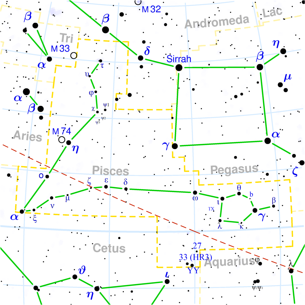
The yellow dashed lines are constellation boundaries, the red dashed line is the ecliptic, and the shades of blue show Milky Way areas of different brightness. The map contains all Messier objects, except for colliding ones. The underlying database contains all stars brighter than 6.5. All coordinates refer to equinox 2000.0.
The map is calculated with the equidistant azimuthal projection (the zenith being in the center of the image). The north pole is to the top. The (horizontal) lines of equal declination are drawn for 0°, ±10°, ±20° etc. The lines of equal right ascension are drawn for all 24 hours. Towards the rim there is a very slight magnification (and distortion).

|
File:Pisces constellation map.svg是本檔案的向量版本。 如果品質不低,就應該優先使用該檔案,而非PNG檔案。
File:Pisces constellation map.png → File:Pisces constellation map.svg
更多資訊請參閱Help:SVG/zh。 |
 |

|
已授權您依據自由軟體基金會發行的無固定段落、封面文字和封底文字GNU自由文件授權條款1.2版或任意後續版本,對本檔進行複製、傳播和/或修改。該協議的副本列在GNU自由文件授權條款中。 |
| 此檔案採用創用CC 姓名標示-相同方式分享 3.0 未在地化版本授權條款。 | ||
| ||
| 已新增授權條款標題至此檔案,作為GFDL授權更新的一部份。 |
derivative works
此檔案衍生的作品: Pisces constellation map.svg
檔案歷史
點選日期/時間以檢視該時間的檔案版本。
| 日期/時間 | 縮圖 | 尺寸 | 使用者 | 備註 | |
|---|---|---|---|---|---|
| 目前 | 2020年11月18日 (三) 20:32 | | 2,559 × 2,559(243 KB) | Adam37 | Added stars from the various pages of wikipedia, hours work to do so, kindly do not delete. |
| 2015年6月21日 (日) 22:28 |  | 2,559 × 2,559(100 KB) | Cmdrjameson | Compressed with pngout. Reduced by 76kB (43% decrease). | |
| 2004年12月12日 (日) 18:23 |  | 2,559 × 2,559(176 KB) | Alfio | Pisces constellation map |
檔案用途
全域檔案使用狀況
以下其他 wiki 使用了這個檔案:
- af.wikipedia.org 的使用狀況
- ar.wikipedia.org 的使用狀況
- ast.wikipedia.org 的使用狀況
- be.wikipedia.org 的使用狀況
- bg.wikipedia.org 的使用狀況
- bn.wikipedia.org 的使用狀況
- ca.wikipedia.org 的使用狀況
- co.wikipedia.org 的使用狀況
- cs.wikipedia.org 的使用狀況
- da.wikipedia.org 的使用狀況
- de.wikipedia.org 的使用狀況
- de.wiktionary.org 的使用狀況
- el.wikipedia.org 的使用狀況
- el.wiktionary.org 的使用狀況
- en.wikipedia.org 的使用狀況
- en.wiktionary.org 的使用狀況
- es.wikipedia.org 的使用狀況
- fa.wikipedia.org 的使用狀況
- fi.wikipedia.org 的使用狀況
- frr.wikipedia.org 的使用狀況
- ga.wikipedia.org 的使用狀況
- gl.wikipedia.org 的使用狀況
- he.wiktionary.org 的使用狀況
- hi.wikipedia.org 的使用狀況
- hr.wikipedia.org 的使用狀況
- hu.wikipedia.org 的使用狀況
- hu.wiktionary.org 的使用狀況
- id.wikipedia.org 的使用狀況
- it.wikipedia.org 的使用狀況
- it.wiktionary.org 的使用狀況
檢視此檔案的更多全域使用狀況。