
File:North-Pacific-air-routes.png
North-Pacific-air-routes.png (500 × 441 像素,檔案大小:34 KB,MIME 類型:image/png)
Transferred from en.wikipedia to Commons by Maksim.
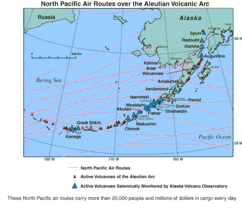
North Pacific air routes over the Aleutian volcanic arc.[1] From the Alaska Volcano Observatory, a joint program of the United States Geological Survey, the Geophysical Institute of the University of Alaska Fairbanks, and the State of Alaska Division of Geological and Geophysical Surveys. This image contained no copyright information and is assumed to be freely available as a USGS image.
![[1]](http://www.avo.alaska.edu/avo4/atlas/volc/spurr/spurr2004/popup.htm?airroutes.jpg)
|
|
| date/time | username | edit summary |
|---|---|---|
| 01:16, 10 February 2005 | en:User:RedWolf | ({{PD-USGov-Interior-USGS}}) |
| 06:18, 4 September 2004 | en:User:Moverton | |
| 05:49, 4 September 2004 | en:User:Moverton | (North Pacific air routes over the Aleutian volcanic arc) |
原始上傳日誌
Legend: (cur) = this is the current file, (del) = delete this old version, (rev) = revert to this old version.
Click on date to download the file or see the image uploaded on that date.
- (del) (cur) 05:49, 4 September 2004 . . en:User:Moverton Moverton ( en:User_talk:Moverton Talk) . . 500x441 (34601 bytes) (North Pacific air routes over the Aleutian volcanic arc)
檔案歷史
點選日期/時間以檢視該時間的檔案版本。
| 日期/時間 | 縮圖 | 尺寸 | 使用者 | 備註 | |
|---|---|---|---|---|---|
| 目前 | 2006年1月24日 (二) 19:44 | | 500 × 441(34 KB) | Maksim | La bildo estas kopiita de wikipedia:en. La originala priskribo estas: ''North Pacific air routes over the Aleutian volcanic arc.[http://www.avo.alaska.edu/avo4/atlas/volc/spurr/spurr2004/popup.htm?airroutes.jpg]'' From the [http://www.avo.alaska.edu/ Al |
檔案用途
下列頁面有用到此檔案:
全域檔案使用狀況
以下其他 wiki 使用了這個檔案:
- bg.wikipedia.org 的使用狀況
- bs.wikipedia.org 的使用狀況
- da.wikipedia.org 的使用狀況
- el.wiktionary.org 的使用狀況
- en.wikipedia.org 的使用狀況
- en.wiktionary.org 的使用狀況
- es.wikipedia.org 的使用狀況
- et.wikipedia.org 的使用狀況
- eu.wikipedia.org 的使用狀況
- fi.wikinews.org 的使用狀況
- fr.wikipedia.org 的使用狀況
- gl.wikipedia.org 的使用狀況
- hr.wikipedia.org 的使用狀況
- is.wikipedia.org 的使用狀況
- kn.wikipedia.org 的使用狀況
- la.wikipedia.org 的使用狀況
- nn.wikipedia.org 的使用狀況
- sh.wikipedia.org 的使用狀況
- te.wikipedia.org 的使用狀況
- tt.wikipedia.org 的使用狀況
- uk.wikipedia.org 的使用狀況
- vi.wikipedia.org 的使用狀況