
File:Korea 2003-05-01 NASA MODIS Terra 250m.jpg

預覽大小:443 × 599 像素。 其他解析度:177 × 240 像素 | 355 × 480 像素 | 568 × 768 像素 | 757 × 1,024 像素 | 1,514 × 2,048 像素 | 3,400 × 4,600 像素。
原始檔案 (3,400 × 4,600 像素,檔案大小:1.47 MB,MIME 類型:image/jpeg)
摘要
| 描述 |
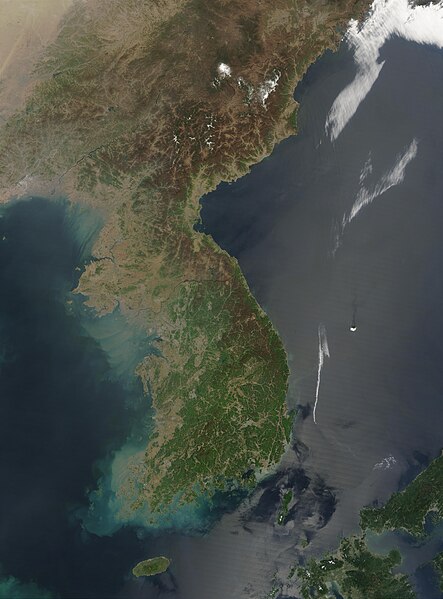
Français : Image satellite de la Corée le 1er mai 2003 par le satellite Terra du programme MODIS de la NASA, résolution 250m
English: This Moderate Resolution Imaging Spectroradiometer (MODIS) image from May 1, 2003, shows southeastern China (top), North Korea (center) and South Korea (bottom). The higher elevations and more northern latitudes are lagging behind the new growth of spring vegetation visible across South Korea. Large areas of North Korea, especially the western coast, are deforested, probably contributing to the large volumes of sediment run-off swirling in the coastal waters. A few scattered fires have been marked with red dots. Resolution 250m |
| 日期 | |
| 來源 | NASA's Visible Earth, https://visibleearth.nasa.gov/images/66392/korea |
| 作者 | Jeff Schmaltz, MODIS Rapid Response Team, NASA/GSFC |
| 拍攝地點 | | 位於此地的本圖片與其他圖片: OpenStreetMap |
|---|
授權條款
| 本作品由NASA創作,屬於公有領域。根據NASA的版權政策:“NASA的創作除非另有聲明否則不受版權保護。”(參見:Template:PD-USGov/zh,NASA版權政策或JPL圖像使用政策) | ||
 |
警告:
|
檔案歷史
點選日期/時間以檢視該時間的檔案版本。
| 日期/時間 | 縮圖 | 尺寸 | 使用者 | 備註 | |
|---|---|---|---|---|---|
| 目前 | 2023年9月25日 (一) 07:18 | | 3,400 × 4,600(1.47 MB) | Koreller | Uploaded own work with UploadWizard |
檔案用途
下列頁面有用到此檔案:
全域檔案使用狀況
以下其他 wiki 使用了這個檔案:
- ar.wikipedia.org 的使用狀況
- ast.wikipedia.org 的使用狀況
- az.wikipedia.org 的使用狀況
- bn.wikipedia.org 的使用狀況
- ca.wikipedia.org 的使用狀況
- csb.wikipedia.org 的使用狀況
- cs.wikipedia.org 的使用狀況
- de.wikipedia.org 的使用狀況
- en.wikipedia.org 的使用狀況
- en.wikiquote.org 的使用狀況
- en.wiktionary.org 的使用狀況
- eo.wikipedia.org 的使用狀況
- es.wikipedia.org 的使用狀況
- eu.wikipedia.org 的使用狀況
- fi.wikipedia.org 的使用狀況
- fr.wikipedia.org 的使用狀況
- ga.wikipedia.org 的使用狀況
- he.wikipedia.org 的使用狀況
- hr.wikipedia.org 的使用狀況
- hu.wikipedia.org 的使用狀況
- hy.wikipedia.org 的使用狀況
- ia.wikipedia.org 的使用狀況
- it.wikipedia.org 的使用狀況
- ja.wikipedia.org 的使用狀況
- ko.wikipedia.org 的使用狀況
- min.wikipedia.org 的使用狀況
- ms.wikipedia.org 的使用狀況
- nds.wikipedia.org 的使用狀況
- no.wikipedia.org 的使用狀況
- pl.wikipedia.org 的使用狀況
- pl.wiktionary.org 的使用狀況
- pnb.wikipedia.org 的使用狀況
- pt.wikipedia.org 的使用狀況
- roa-tara.wikipedia.org 的使用狀況
- ru.wikipedia.org 的使用狀況
- ru.wikinews.org 的使用狀況
檢視此檔案的更多全域使用狀況。