
File:North-Pacific-air-routes.png
没有更高的分辨率。
North-Pacific-air-routes.png (500 × 441像素,文件大小:34 KB,MIME类型:image/png)
本檔案是由Maksim從en.wikipedia轉移到維基共享資源。
原始描述頁面位於這裡。下列使用者名稱均來自en.wikipedia。
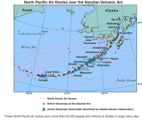
North Pacific air routes over the Aleutian volcanic arc.[1] From the Alaska Volcano Observatory, a joint program of the United States Geological Survey, the Geophysical Institute of the University of Alaska Fairbanks, and the State of Alaska Division of Geological and Geophysical Surveys. This image contained no copyright information and is assumed to be freely available as a USGS image.
![[1]](http://www.avo.alaska.edu/avo4/atlas/volc/spurr/spurr2004/popup.htm?airroutes.jpg)
|
|
| date/time | username | edit summary |
|---|---|---|
| 01:16, 10 February 2005 | en:User:RedWolf | ({{PD-USGov-Interior-USGS}}) |
| 06:18, 4 September 2004 | en:User:Moverton | |
| 05:49, 4 September 2004 | en:User:Moverton | (North Pacific air routes over the Aleutian volcanic arc) |
原始上传日志
Legend: (cur) = this is the current file, (del) = delete this old version, (rev) = revert to this old version.
Click on date to download the file or see the image uploaded on that date.
- (del) (cur) 05:49, 4 September 2004 . . en:User:Moverton Moverton ( en:User_talk:Moverton Talk) . . 500x441 (34601 bytes) (North Pacific air routes over the Aleutian volcanic arc)
文件历史
点击某个日期/时间查看对应时刻的文件。
| 日期/时间 | 缩略图 | 大小 | 用户 | 备注 | |
|---|---|---|---|---|---|
| 当前 | 2006年1月24日 (二) 19:44 | | 500 × 441(34 KB) | Maksim | La bildo estas kopiita de wikipedia:en. La originala priskribo estas: ''North Pacific air routes over the Aleutian volcanic arc.[http://www.avo.alaska.edu/avo4/atlas/volc/spurr/spurr2004/popup.htm?airroutes.jpg]'' From the [http://www.avo.alaska.edu/ Al |
文件用途
以下页面链接到本图像:
全域文件用途
以下其他wiki使用此文件:
- bg.wikipedia.org上的用途
- bs.wikipedia.org上的用途
- da.wikipedia.org上的用途
- el.wiktionary.org上的用途
- en.wikipedia.org上的用途
- en.wiktionary.org上的用途
- es.wikipedia.org上的用途
- et.wikipedia.org上的用途
- eu.wikipedia.org上的用途
- fi.wikinews.org上的用途
- fr.wikipedia.org上的用途
- gl.wikipedia.org上的用途
- hr.wikipedia.org上的用途
- is.wikipedia.org上的用途
- kn.wikipedia.org上的用途
- la.wikipedia.org上的用途
- nn.wikipedia.org上的用途
- sh.wikipedia.org上的用途
- te.wikipedia.org上的用途
- tt.wikipedia.org上的用途
- uk.wikipedia.org上的用途
- vi.wikipedia.org上的用途