
File:City of Carauari, the Juruá River and its tributaries, taken from the International Space Station.jpg

本预览的尺寸:800 × 529像素。 其他分辨率:320 × 212像素 | 640 × 423像素 | 1,024 × 677像素 | 1,280 × 846像素 | 3,032 × 2,005像素。
原始文件 (3,032 × 2,005像素,文件大小:1.17 MB,MIME类型:image/jpeg)
摘要
| 描述 |
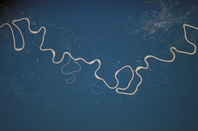
English: NASA Astronaut Photography of Earth - Display Record ISS015-E-15057, Carauari, Amazonas, Brazil. Showing the city of Carauari, the Juruá River and its tributaries. From International Space Station (Expedition 15). Latitude (LAT): -4.5, Longitude (LON): -67.5, Altitude (ALT): 178 Nautical Miles, Sun Azimuth (AZI): 62°, Sun Elevation Angle (ELEV): 24° |
|||||||
| 日期 | ||||||||
| 来源 | http://eol.jsc.nasa.gov/scripts/sseop/photo.pl?mission=ISS015&roll=E&frame=15057 also http://chamorrobible.org/gpw/gpw-200702-English.htm for cropped version | |||||||
| 作者 | Image Science and Analysis Laboratory, NASA-Johnson Space Center. "The Gateway to Astronaut Photography of Earth." | |||||||
| 授权 (二次使用本文件) |
|

| 相机位置 | | 在以下服务上查看本图像和附近其他图像: OpenStreetMap |
|---|
文件历史
点击某个日期/时间查看对应时刻的文件。
| 日期/时间 | 缩略图 | 大小 | 用户 | 备注 | |
|---|---|---|---|---|---|
| 当前 | 2008年3月18日 (二) 19:49 | | 3,032 × 2,005(1.17 MB) | WarBaCoN | |
| 2008年3月18日 (二) 19:47 |  | 3,032 × 2,064(917 KB) | WarBaCoN | {{Information |Description=NASA Astronaut Photography of Earth - Display Record ISS015-E-15057, Amazon Basin, Brazil. Showing river, tributaries, rainforest, jungle. From International Space Station (Expedition 15). Latitude (LAT): -4.5, Longitude (LON |
文件用途
以下页面链接到本图像:
全域文件用途
以下其他wiki使用此文件:
- bg.wikipedia.org上的用途
- en.wikipedia.org上的用途
- en.wiktionary.org上的用途
- es.wikipedia.org上的用途
- nl.wikipedia.org上的用途
- oc.wikipedia.org上的用途
- pt.wikipedia.org上的用途
- uz.wikipedia.org上的用途