
File:Venice Lagoon December 9 2001.jpg
本预览的尺寸:512 × 599像素。 其他分辨率:205 × 240像素 | 410 × 480像素 | 656 × 768像素 | 875 × 1,024像素 | 1,750 × 2,048像素 | 3,580 × 4,189像素。
原始文件 (3,580 × 4,189像素,文件大小:11.35 MB,MIME类型:image/jpeg)
摘要
| 描述 |
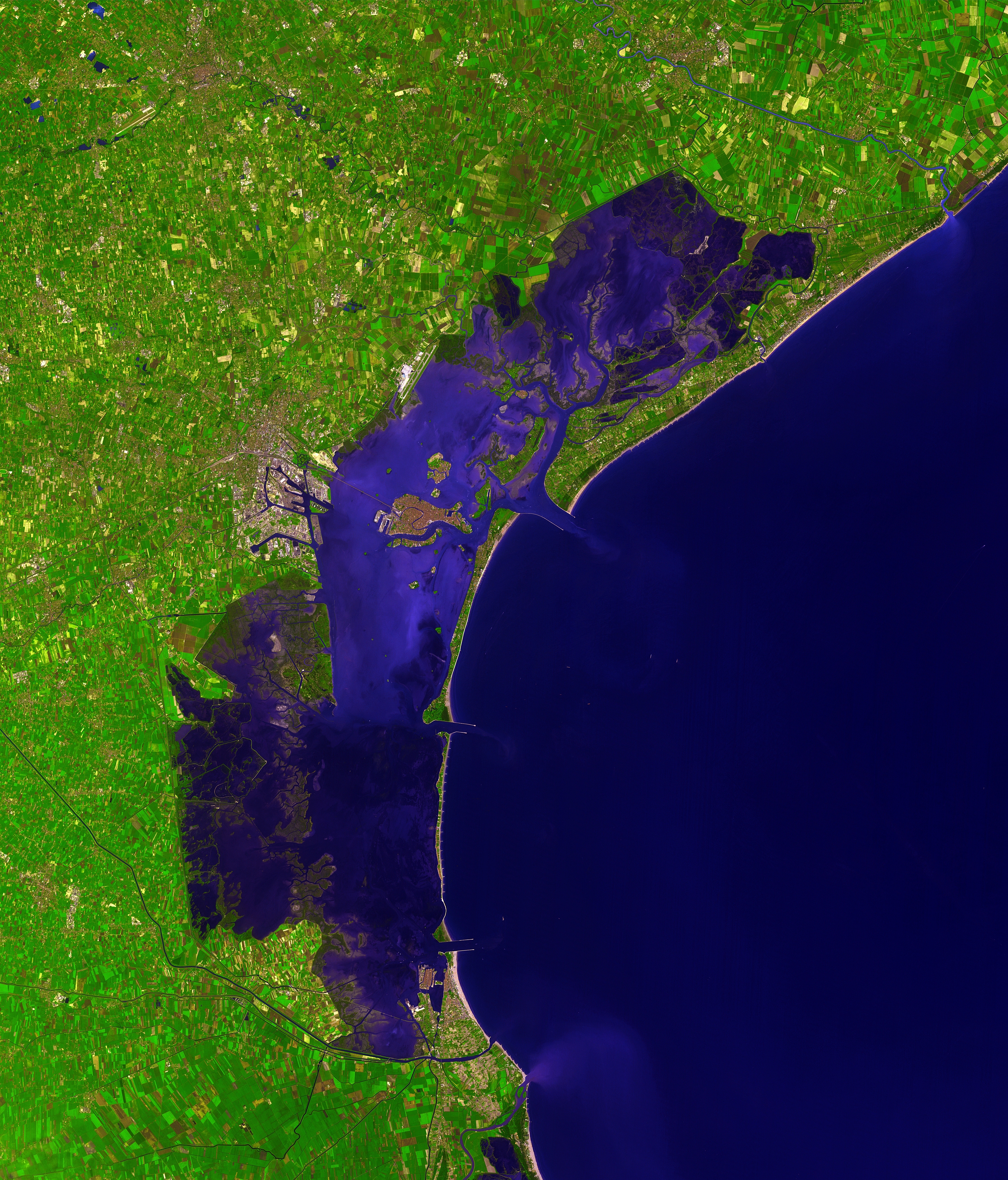
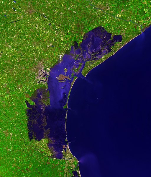
Deutsch: Dieses Satellitenbild der Lagune von Venedig wurde von ASTER (Advanced Spaceborne Thermal Emission and Reflection Radiometer) aufgenommen, einem Aufnahmesystem an Bord des Satelliten Terra der Teil des NASA Earth Observing System (EOS) ist. Das Bild wurde am 9. Dezember 2001 erstellt und deckt eine Fläche von 39 x 35 km ab. (Simulierte Naturfarben)
English: This picture of the Venetian Lagoon was taken by ASTER (Advanced Spaceborne Thermal Emission and Reflection Radiometer), an imaging instrument flying on Terra, a satellite part of NASA's Earth Observing System (EOS). It covers an area of 39 x 35 km and was acquired on December 9, 2001. (simulated natural color)
Français : Image de la lagune de Venise prise par l'instrument d'imagerie ASTER (Advanced Spaceborne Thermal Emission and Reflection Radiometer) embarqué sur le satellite Terra, lancé dans le cadre du programme EOS (Earth Observing System, ou Système d'Observation de la Terre). Aire couverte: 39 x 35 km, Couleurs naturelles simulées. Image prise le 9 décembre 2001.
Italiano: Questa immagine della Laguna di Venezia è stata ripresa da ASTER (Advanced Spaceborne Thermal Emission and Reflection Radiometer), uno strumento installato su Terra, un satellite della NASA Earth Observing System (EOS). Copre un'area di 39 x 35 km ed è stata ripresa il 9 dicembre 2001. (colori naturali simulati) |
| 日期 | |
| 来源 | http://earthobservatory.nasa.gov/Newsroom/NewImages/images.php3?img_id=16314 |
| 作者 | NASA/GSFC/MITI/ERSDAC/JAROS, and U.S./Japan ASTER Science Team |
| 其他版本 |
 |
| 相机位置 | | 在以下服务上查看本图像和附近其他图像: OpenStreetMap |
|---|
|

本图像被选为2007年9月15日的今日图片。其说明如下: English: Satellite photo of the Venetian Lagoon. 其他语言:
Asturianu: Semeya satelital de la Llaguna de Venecia Deutsch: Satellitenbild der Lagune von Venedig English: Satellite photo of the Venetian Lagoon. Español: Fotografía de satélite de la laguna de Venecia. Euskara: Veneziako badia satelitetik ikusia Français : La lagune de Venise vue par satellite Íslenska: Gervihnattamynd af Feneyjalóni. Italiano: Foto satellitare della laguna di Venezia. Magyar: A velencei lagúna műholdas képe (39 x 35 km-es terület, szinezve, 2001. december 9.) Беларуская: Венецыянская лагуна, здымак з космасу. Русский: Венецианская лагуна, снимок из космоса |
许可协议
| 本文件完全由NASA创作,在美国属于公有领域。根据NASA的版权方针,NASA的材料除非另有声明否则不受版权保护。(参见Template:PD-USGov/zh、NASA版权方针页面或JPL图片使用方针。) | ||
 |
警告:
|
| 註解 | 該圖片含有註解:在維基媒體共享資源上查看註解 |

文件历史
点击某个日期/时间查看对应时刻的文件。
| 日期/时间 | 缩略图 | 大小 | 用户 | 备注 | |
|---|---|---|---|---|---|
| 当前 | 2006年12月7日 (四) 15:41 | | 3,580 × 4,189(11.35 MB) | AlMare | Cropped |
| 2006年11月13日 (一) 11:46 |  | 3,598 × 4,200(11.09 MB) | AlMare | ||
| 2006年11月10日 (五) 14:14 |  | 3,598 × 4,200(8.42 MB) | AlMare | {{en|This picture of the en:Venetian Lagoon was taken by ASTER (Advanced Spaceborne Thermal Emission and Reflection Radiometer), an imaging instrument flying on Terra, a satellite part of NASA's Earth Observing System |
文件用途
没有页面链接到本图像。
全域文件用途
以下其他wiki使用此文件:
- ar.wikipedia.org上的用途
- ast.wikipedia.org上的用途
- ba.wikipedia.org上的用途
- be.wikipedia.org上的用途
- bg.wikipedia.org上的用途
- bn.wikipedia.org上的用途
- bn.wikibooks.org上的用途
- br.wikipedia.org上的用途
- ca.wikipedia.org上的用途
- cs.wikipedia.org上的用途
- cy.wikipedia.org上的用途
- de.wikipedia.org上的用途
- de.wiktionary.org上的用途
- el.wikipedia.org上的用途
- en.wikipedia.org上的用途
- en.wiktionary.org上的用途
- eo.wikipedia.org上的用途
- eo.wikivoyage.org上的用途
- et.wikipedia.org上的用途
- fa.wikibooks.org上的用途
- fi.wikipedia.org上的用途
- fi.wiktionary.org上的用途
- frr.wikipedia.org上的用途
- fr.wikipedia.org上的用途
- fy.wikipedia.org上的用途
- gl.wikipedia.org上的用途
- hi.wikipedia.org上的用途
- hr.wikipedia.org上的用途
- hu.wikipedia.org上的用途
查看本文件的更多全域用途。