
File:Satellite image of Philippines in March 2002.jpg

本预览的尺寸:460 × 600像素。 其他分辨率:184 × 240像素 | 368 × 480像素 | 589 × 768像素 | 785 × 1,024像素 | 1,570 × 2,048像素 | 4,600 × 6,000像素。
原始文件 (4,600 × 6,000像素,文件大小:3.58 MB,MIME类型:image/jpeg)
摘要
| 描述 |
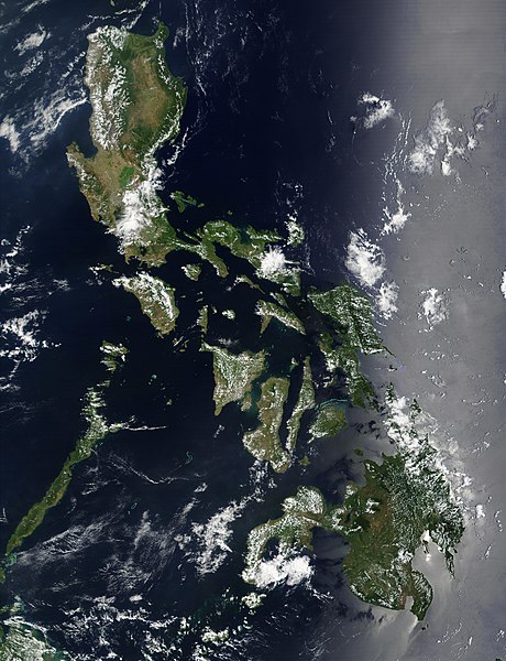
Satellite image of Philippines in March 2002. |
| 日期 | |
| 来源 | http://visibleearth.nasa.gov/view_rec.php?id=2689 |
| 作者 | NASA |
许可协议
| 本文件完全由NASA创作,在美国属于公有领域。根据NASA的版权方针,NASA的材料除非另有声明否则不受版权保护。(参见Template:PD-USGov/zh、NASA版权方针页面或JPL图片使用方针。) | ||
 |
警告:
|
文件历史
点击某个日期/时间查看对应时刻的文件。
| 日期/时间 | 缩略图 | 大小 | 用户 | 备注 | |
|---|---|---|---|---|---|
| 当前 | 2004年12月21日 (二) 11:32 | | 4,600 × 6,000(3.58 MB) | Hautala | {{PD-USGov-NASA}} Satellite image of Philippines in March 2002. Taken from NASA's Visible Earth http://visibleearth.nasa.gov/cgi-bin/viewrecord?12847 . Description: Red dots (or outlines in the high-resolution imagery) indicate MODIS9 detection of thermal |
文件用途
以下页面链接到本图像:
全域文件用途
以下其他wiki使用此文件:
- af.wikipedia.org上的用途
- bg.wikipedia.org上的用途
- bn.wikipedia.org上的用途
- ca.wikipedia.org上的用途
- da.wikipedia.org上的用途
- de.wikipedia.org上的用途
- de.wikinews.org上的用途
- en.wikipedia.org上的用途
- Outline of the Philippines
- Deforestation by continent
- Deforestation in the Philippines
- Wikipedia:Featured picture candidates/Satellite image of the Philippines
- Wikipedia:Featured picture candidates/September-2012
- Wikipedia:Featured picture candidates/February-2014
- Wikipedia:Featured picture candidates/Philippines (Satellite)
- en.wikiversity.org上的用途
- en.wiktionary.org上的用途
- fi.wikipedia.org上的用途
- gl.wikipedia.org上的用途
- he.wikipedia.org上的用途
- תבנית:הידעת? 5 בנובמבר - סדרה 2
- פורטל:ארצות הברית/הידעת?/קטעי הידעת
- פורטל:ארצות הברית/הידעת?/50
- פורטל:יפן/הידעת?/קטעי הידעת
- תבנית:הידעת? 5 בנובמבר 2014
- ויקיפדיה:הידעת?/2014/נובמבר
- ויקיפדיה:הידעת?/2016/נובמבר
- תבנית:הידעת? 5 בנובמבר 2016
- ויקיפדיה:הידעת?/2018/נובמבר
- תבנית:הידעת? 18 בנובמבר 2018
- תבנית:הידעת? 1 בנובמבר 2019
- ויקיפדיה:הידעת?/2019/נובמבר
- ויקיפדיה:הידעת?/2021/נובמבר
- תבנית:הידעת? 7 בנובמבר 2021
- פורטל:יפן/הידעת?/23
- תבנית:הידעת? 5 בנובמבר 2023
- ויקיפדיה:הידעת?/2023/נובמבר
- ht.wikipedia.org上的用途
- incubator.wikimedia.org上的用途
- mdf.wikipedia.org上的用途
- nl.wikipedia.org上的用途
- nl.wiktionary.org上的用途
- no.wikipedia.org上的用途
- pap.wikipedia.org上的用途
- pl.wikinews.org上的用途
- qu.wikipedia.org上的用途
- sk.wikipedia.org上的用途
- sm.wikipedia.org上的用途
- sr.wikinews.org上的用途
查看本文件的更多全域用途。